Protecting heritage sites from damage and destruction poses a unique set of challenges. The Islamic State (ISIS) is an example of a group causing willful destruction of antiquities and with swathes of the Middle East in conflict, sites which have stood for millennia are being destroyed – sometimes deliberately – on a daily basis.
Heritage sites are also lost to storms, earthquakes, decay, development, lack of proper care and many other causes.
CyArk’s mission is to both preserve heritage for future generations and make it accessible to today’s public.
The non-profit organisation was founded in 2003 and uses cutting-edge technologies to create detailed 3D representations of significant cultural heritage sites before they’re damaged or destroyed by natural disasters, conflicts or the passage of time.
To create the representations that help preserve these sites for the future, CyArk uses an advanced system of laser scanners to mark millions of points that create an almost perfect 3D data set, which can then be used to create a solid 3D model.
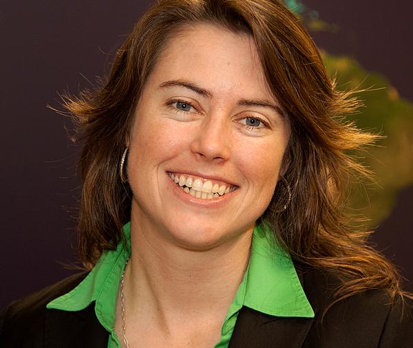
Elizabeth Lee, vice president at CyArk, explains what measures the company is taking to protect the world’s cultural heritage from disappearing completely.
What is CyArk? CyArk is a non-profit foundation with offices in the US and UK. Our mission is to use new technologies to digitally capture and preserve cultural heritage sites around the world. The principal technology that we employ is 3D capture using lasers and photography to create a detailed and highly accurate record of sites and monuments.
We archive all the data so if anything happened to these sites, we have engineering-grade data that can be used to reconstruct them. In the meantime, that same 3D data can be used for outputs like education and cultural tours.
Do you mean “reconstruct” the sites virtually or in reality? The latter. If something were to fall down, the documentation we have is accurate enough to put into a traditional architectural drawing, which could then be used to reconstruct the monument.
How does funding work for you? We’re fundraising all the time. We plan fundraising events around specific projects, but our funding comes from a number of sources, such as government grants, corporate and individual donations and support from our technology partners.
Who are your technology partners? CyArk was founded by Ben Kacyra, a pioneer in bringing 3D laser scanning technology to the market via his commercial company, Cyra Technologies.
That company was acquired in 2001 by a surveying company called Leica Geosystems. We still work with them and with many of the other manufacturers of this tech, such as Trimble, Autodesk, Faro, Topcon – some of the big survey companies. On the archiving and data storage, we work with Iron Mountain and others.
What’s the cost of mapping one site? The costs are changing all the time and the technology is improving. To do everything from capturing in the field to processing the data then getting it online used to have a ballpark figure of $50,000 (£34,000, €47,000) per project. However, we’re seeing those figures start to really come down. We work through local partner agencies, service providers and universities so that’s another way that price is continuing to drop.
What’s the rough cost now? It’s closer to $30,000 to $40,000 (£20,000 to £27,000, €28,000 to €38,000) per project. That includes everything from the capture, to processing the data. On certain projects we do a “scan and can” – just capturing the data and archiving it for the future – and that can be done, in some cases, for less than $10,000 (£6,800, €9,400) per site.
You’ve been operating for more than 10 years. How much has been spent so far on mapping these sites? About $10m to $15m (£7m to £10m, €9m to €14m), in terms of cash investment, as well the technology and other kinds of supporting donations that we’ve received.
How do you manage to make large amounts of data available to the public? One of the things that we prioritised from the beginning is making the archive accessible, particularly over the Web. We’ve spent a lot of time figuring out ways to manipulate the data and create derivatives from it that are easily shared and then consumed by the public.
In some cases we’ll develop lighter-weight or decimated versions of the 3D data and put that online. Sometimes we show the site with a fly-through animation or video, but there are different ways to make the data accessible, even if you’re not able to put a really large data set up online.
How does the scanning work from a commercial standpoint? We haven’t explored that too much yet. Our focus has been on building the archive and having that information available, should it be needed for the future. One of the things we’re starting to see both in museums and other similar venues is there may be a real opportunity to license this data in a way that is both respectful to and generates revenue back to the site so they can also benefit from it.
How big is one project in terms of data size? Several terabytes per project. Some are a lot bigger and some are smaller, but very few projects now are under a terabyte.
We have capacity for two petabytes and right now we’re at a couple of hundred terabytes. We can always expand.
You’ve done apps in conjunction with specific projects. Is that another way to share the data with the public? There’s always interest about how people are interacting with information and we try to get it to them in a format that’s relevant. We’ve worked on the mobile side and apps are great, particularly with some of the sites where connectivity is low. If you’re not going to get a good signal to pull up information on your phone, you can download the content of an app before you travel and augment your experience on site with this 3D data and the educational content we’ve developed.
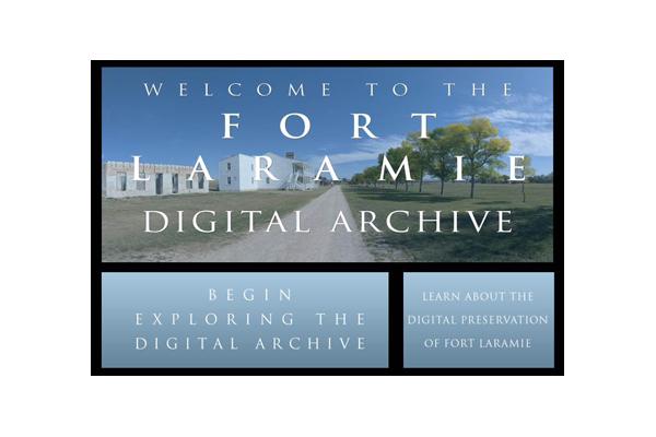
Fort Laramie in Wyoming, US, for example, has an iPhone and iPad app with 67 panoramic images, a detailed site map, 3D laser scan data and virtual fly-throughs.
With a lot of sites it’s something that comes out of the discussion we have with the site operators. If there’s a need and it can be beneficial, we try to get it done.
What partners do you have? We’ve worked with a number of museums. We’ve started a research and development project with the British Museum looking at similar technology to scan collections to better document and interpret them. Other museums we’ve worked with are more about showcasing the content in a museum setting. We’ve done some work with the Ars Electronica museum in Austria, doing life-size 3D projections of a handful of the sites within our archive.
How easy is getting access to sites? If there was one body that could control access to all the sites, that would make things a lot easier, but the reality is that we have to work with different national and local governments and organisations that manage the sites. We spend a good amount of time co-ordinating things with the site authorities or representatives to get the access that we need. Those meetings also help us establish what output they would like to see for their site.
How many projects have you mapped? We’ve got 130 sites to date in the archive and we launched an initiative last year called the CyArk 500 with the objective of scanning 500 sites over the next five years.
Would you do underwater mapping? That technology is really exciting and getting better all the time. Applying underwater mapping tech to things like shipwrecks and submerged cities is possible. We don’t have any projects in the works right now but we would love to.
As for the documentation, does that get digitised? There’s always a big effort to capture additional photographic information and historic data and narratives. All that’s archived digitally so we can easily share it.
What is the overarching aim of CyArk? Is it to present history, to preserve it? Or both? It’s both. The primary focus is on preserving it. The focus is on going out and getting that information in the archive to preserve it. If we don’t have that record it’s very hard to interpret down the road. If we have that record we can always add to it, but if it’s not here in the first place we’re in danger of losing a piece of our history.
Have you entered sites where an element of danger is present? There’s a huge need to capture information in these areas. Ideally we’d capture information before a conflict arises. We haven’t had much experience going into active conflict zones because it’s just too dangerous. We’ve gone into higher-risk areas to capture information but there’s a line between high risk and active zones.
In 2010 a team went to Babylon, Iraq, an area that was still fairly risky, but it was safe enough to do the capture. We’ve also done recent work in Somaliland as well.
Do you have any other comments? We’re very interested to see how this data can be used in other applications and we really want to call on people to participate in the CyArk 500 by nominating sites.
WHAT ARE CYARK TECHNOLOGY CENTRES? CyArk Technology Centres are a partnership between CyArk and a university, community college or high school. The centres build skilled teams to help with CyArk’s digital preservation movement, and transfer skill sets in technology into the local workforce. CyArk says the programme benefits a range of studies, including historical preservation, anthropology, archaeology, architecture, the STEM topics and environmental and spatial technologies (EAST).
Students gain exposure to brand new technologies, training in the latest software and hardware, training in advanced documentation methodology, advanced skill development and CyArk certification.
KwaZulu-Natal University in Durban, South Africa, is a CyArk Technology Centre partner
WHAT IS THE CYARK 500?
CyArk 500 hopes to preserve 500 heritage sites worldwide over the course of the next five years. CyArk wants to preserve these sites from war, terrorism, arson, urban sprawl, climate change, earthquakes, floods and other threats, particularly in areas that could become too dangerous to map.
Members of the heritage community can submit sites for consideration. Governments, organisations and individuals can nominate. The sites will be assessed and selected by an Advisory Council according to the criteria they helped develop.
CyArk has completed 40 projects of the 500, including Pompeii, Babylon, Mount Rushmore, the Leaning Tower of Pisa, the Titanic wreck, the Sydney Opera House and the Tower of London.
The feasibility of doing projects depends on access and funding. CyArk points out that it might be easier to raise funds for some sites than others.
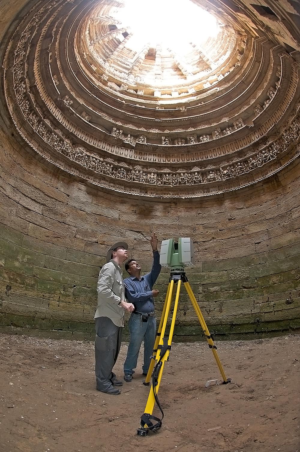
CyArk partners from the Archaeological Survey of India and Scottish Ten at Rani-ki-Vav well, Gujarat, India Credit: PHOTO CREDIT: CDDV
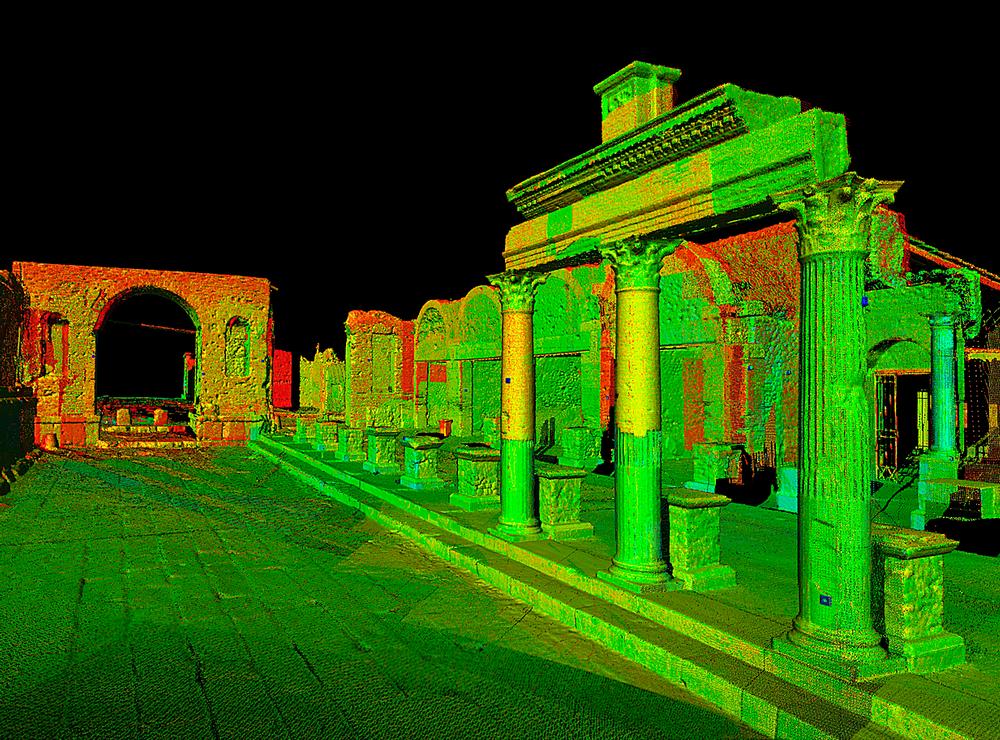
Digital images of Pompeii, Italy
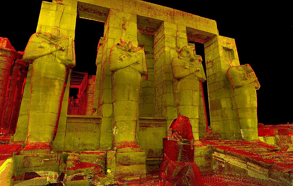
Digital images of Ancient Thebes, Egypt
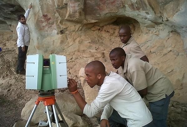
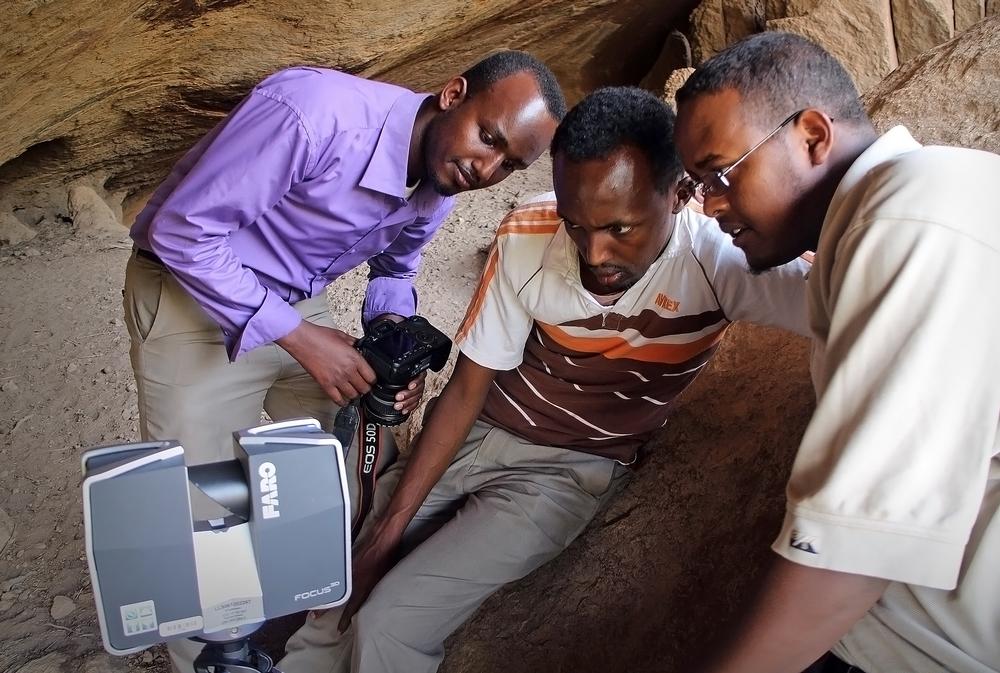
CyArk carry out field work in Somaliland, where the team document rock art sites, some of the first examples of writing in East Africa
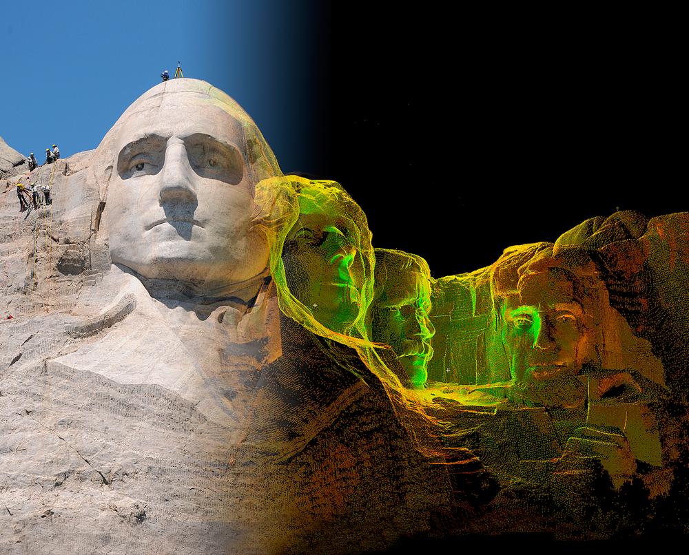
Mount Rushmore in South Dakota, US, was scanned by CyArk in 2010. The memorial suffers fracturing and cracking because of the fineness of the granite
The Fort Laramie app for iPhone and iPad augments the on-site experience, providing audio and virtual access to off-bounds areas
COMPANY PROFILES
Alterface
Alterface’s Creative Division team is
seasoned in concept and ride development,
as well as storyte [more...]
QubicaAMF UK
QubicaAMF is the largest and most
innovative bowling equipment provider with
600 employees worldwi [more...]
Protecting heritage sites from damage and destruction poses a unique set of challenges. The Islamic State (ISIS) is an example of a group causing willful destruction of antiquities and with swathes of the Middle East in conflict, sites which have stood for millennia are being destroyed – sometimes deliberately – on a daily basis.
Heritage sites are also lost to storms, earthquakes, decay, development, lack of proper care and many other causes.
CyArk’s mission is to both preserve heritage for future generations and make it accessible to today’s public.
The non-profit organisation was founded in 2003 and uses cutting-edge technologies to create detailed 3D representations of significant cultural heritage sites before they’re damaged or destroyed by natural disasters, conflicts or the passage of time.
To create the representations that help preserve these sites for the future, CyArk uses an advanced system of laser scanners to mark millions of points that create an almost perfect 3D data set, which can then be used to create a solid 3D model.
Elizabeth Lee, vice president at CyArk, explains what measures the company is taking to protect the world’s cultural heritage from disappearing completely.
What is CyArk? CyArk is a non-profit foundation with offices in the US and UK. Our mission is to use new technologies to digitally capture and preserve cultural heritage sites around the world. The principal technology that we employ is 3D capture using lasers and photography to create a detailed and highly accurate record of sites and monuments.
We archive all the data so if anything happened to these sites, we have engineering-grade data that can be used to reconstruct them. In the meantime, that same 3D data can be used for outputs like education and cultural tours.
Do you mean “reconstruct” the sites virtually or in reality? The latter. If something were to fall down, the documentation we have is accurate enough to put into a traditional architectural drawing, which could then be used to reconstruct the monument.
How does funding work for you? We’re fundraising all the time. We plan fundraising events around specific projects, but our funding comes from a number of sources, such as government grants, corporate and individual donations and support from our technology partners.
Who are your technology partners? CyArk was founded by Ben Kacyra, a pioneer in bringing 3D laser scanning technology to the market via his commercial company, Cyra Technologies.
That company was acquired in 2001 by a surveying company called Leica Geosystems. We still work with them and with many of the other manufacturers of this tech, such as Trimble, Autodesk, Faro, Topcon – some of the big survey companies. On the archiving and data storage, we work with Iron Mountain and others.
What’s the cost of mapping one site? The costs are changing all the time and the technology is improving. To do everything from capturing in the field to processing the data then getting it online used to have a ballpark figure of $50,000 (£34,000, €47,000) per project. However, we’re seeing those figures start to really come down. We work through local partner agencies, service providers and universities so that’s another way that price is continuing to drop.
What’s the rough cost now? It’s closer to $30,000 to $40,000 (£20,000 to £27,000, €28,000 to €38,000) per project. That includes everything from the capture, to processing the data. On certain projects we do a “scan and can” – just capturing the data and archiving it for the future – and that can be done, in some cases, for less than $10,000 (£6,800, €9,400) per site.
You’ve been operating for more than 10 years. How much has been spent so far on mapping these sites? About $10m to $15m (£7m to £10m, €9m to €14m), in terms of cash investment, as well the technology and other kinds of supporting donations that we’ve received.
How do you manage to make large amounts of data available to the public? One of the things that we prioritised from the beginning is making the archive accessible, particularly over the Web. We’ve spent a lot of time figuring out ways to manipulate the data and create derivatives from it that are easily shared and then consumed by the public.
In some cases we’ll develop lighter-weight or decimated versions of the 3D data and put that online. Sometimes we show the site with a fly-through animation or video, but there are different ways to make the data accessible, even if you’re not able to put a really large data set up online.
How does the scanning work from a commercial standpoint? We haven’t explored that too much yet. Our focus has been on building the archive and having that information available, should it be needed for the future. One of the things we’re starting to see both in museums and other similar venues is there may be a real opportunity to license this data in a way that is both respectful to and generates revenue back to the site so they can also benefit from it.
How big is one project in terms of data size? Several terabytes per project. Some are a lot bigger and some are smaller, but very few projects now are under a terabyte.
We have capacity for two petabytes and right now we’re at a couple of hundred terabytes. We can always expand.
You’ve done apps in conjunction with specific projects. Is that another way to share the data with the public? There’s always interest about how people are interacting with information and we try to get it to them in a format that’s relevant. We’ve worked on the mobile side and apps are great, particularly with some of the sites where connectivity is low. If you’re not going to get a good signal to pull up information on your phone, you can download the content of an app before you travel and augment your experience on site with this 3D data and the educational content we’ve developed.
Fort Laramie in Wyoming, US, for example, has an iPhone and iPad app with 67 panoramic images, a detailed site map, 3D laser scan data and virtual fly-throughs.
With a lot of sites it’s something that comes out of the discussion we have with the site operators. If there’s a need and it can be beneficial, we try to get it done.
What partners do you have? We’ve worked with a number of museums. We’ve started a research and development project with the British Museum looking at similar technology to scan collections to better document and interpret them. Other museums we’ve worked with are more about showcasing the content in a museum setting. We’ve done some work with the Ars Electronica museum in Austria, doing life-size 3D projections of a handful of the sites within our archive.
How easy is getting access to sites? If there was one body that could control access to all the sites, that would make things a lot easier, but the reality is that we have to work with different national and local governments and organisations that manage the sites. We spend a good amount of time co-ordinating things with the site authorities or representatives to get the access that we need. Those meetings also help us establish what output they would like to see for their site.
How many projects have you mapped? We’ve got 130 sites to date in the archive and we launched an initiative last year called the CyArk 500 with the objective of scanning 500 sites over the next five years.
Would you do underwater mapping? That technology is really exciting and getting better all the time. Applying underwater mapping tech to things like shipwrecks and submerged cities is possible. We don’t have any projects in the works right now but we would love to.
As for the documentation, does that get digitised? There’s always a big effort to capture additional photographic information and historic data and narratives. All that’s archived digitally so we can easily share it.
What is the overarching aim of CyArk? Is it to present history, to preserve it? Or both? It’s both. The primary focus is on preserving it. The focus is on going out and getting that information in the archive to preserve it. If we don’t have that record it’s very hard to interpret down the road. If we have that record we can always add to it, but if it’s not here in the first place we’re in danger of losing a piece of our history.
Have you entered sites where an element of danger is present? There’s a huge need to capture information in these areas. Ideally we’d capture information before a conflict arises. We haven’t had much experience going into active conflict zones because it’s just too dangerous. We’ve gone into higher-risk areas to capture information but there’s a line between high risk and active zones.
In 2010 a team went to Babylon, Iraq, an area that was still fairly risky, but it was safe enough to do the capture. We’ve also done recent work in Somaliland as well.
Do you have any other comments? We’re very interested to see how this data can be used in other applications and we really want to call on people to participate in the CyArk 500 by nominating sites.
WHAT ARE CYARK TECHNOLOGY CENTRES? CyArk Technology Centres are a partnership between CyArk and a university, community college or high school. The centres build skilled teams to help with CyArk’s digital preservation movement, and transfer skill sets in technology into the local workforce. CyArk says the programme benefits a range of studies, including historical preservation, anthropology, archaeology, architecture, the STEM topics and environmental and spatial technologies (EAST).
Students gain exposure to brand new technologies, training in the latest software and hardware, training in advanced documentation methodology, advanced skill development and CyArk certification.
KwaZulu-Natal University in Durban, South Africa, is a CyArk Technology Centre partner
WHAT IS THE CYARK 500?
CyArk 500 hopes to preserve 500 heritage sites worldwide over the course of the next five years. CyArk wants to preserve these sites from war, terrorism, arson, urban sprawl, climate change, earthquakes, floods and other threats, particularly in areas that could become too dangerous to map.
Members of the heritage community can submit sites for consideration. Governments, organisations and individuals can nominate. The sites will be assessed and selected by an Advisory Council according to the criteria they helped develop.
CyArk has completed 40 projects of the 500, including Pompeii, Babylon, Mount Rushmore, the Leaning Tower of Pisa, the Titanic wreck, the Sydney Opera House and the Tower of London.
The feasibility of doing projects depends on access and funding. CyArk points out that it might be easier to raise funds for some sites than others.
CyArk partners from the Archaeological Survey of India and Scottish Ten at Rani-ki-Vav well, Gujarat, India Credit: PHOTO CREDIT: CDDV
Digital images of Pompeii, Italy
Digital images of Ancient Thebes, Egypt
CyArk carry out field work in Somaliland, where the team document rock art sites, some of the first examples of writing in East Africa
Mount Rushmore in South Dakota, US, was scanned by CyArk in 2010. The memorial suffers fracturing and cracking because of the fineness of the granite
The Fort Laramie app for iPhone and iPad augments the on-site experience, providing audio and virtual access to off-bounds areas
Off the back of the success of the first round of Everyday Heritage Grants in 2022, Historic
England is funding 56 creative projects that honour the heritage of working-class England.
Universal has revealed it will be adding new Harry Potter attractions, alongside Super Nintendo
and How to Train Your Dragon worlds to its Florida resort.
Populous have unveiled their plans for a state-of-the-art e-sports arena, designed to stand as a
central landmark in Qiddaya City’s gaming and e-sports district, Saudi Arabia.
Immersive entertainment specialists, Layered Reality, is creating a tribute to Elvis Presley
featuring a concert experience with a life-sized digital Elvis.